Search
With more than 1.2 million illnesses and 29,000 deaths in sub-Saharan Africa in 2017, typhoid fever continues to be a major public health problem. Effective control of the disease would benefit from an understanding of the subnational geospatial distribution of the disease incidence.
Post-tuberculosis (TB) sequelae present a significant challenge in the management of TB survivors, often leading to persistent health issues even after successful treatment. Identifying risk factors associated with post-TB sequelae is important for improving outcomes and quality of life of TB survivors. This systematic review and meta-analysis aims to identify risk factors associated with long-term physical sequelae among TB survivors.
Fertility rates are key indicators of population health and demographic change, influencing economic development, healthcare planning, and social policies. Understanding subnational variation in fertility rate is important for effective geographical targeting and policy prioritization. This study aimed to identify geographic variation, trends, and determinants of fertility rates in Ethiopia over the past two decades.
Climatic conditions are a key determinant of malaria transmission intensity, through their impacts on both the parasite and its mosquito vectors. Mathematical models relating climatic conditions to malaria transmission can be used to develop spatial maps of climatic suitability for malaria. These maps underpin efforts to quantify the distribution and burden of malaria in humans, enabling improved monitoring and control.
This study adds to the current literature by using a novel device-based method to explore where preschool children are physically active outside of home and childcare settings. This study combined accelerometry with geospatial data to explore the influence of the environment on preschool children's physical activity by objectively identifying the locations where preschool children engage in moderate to vigorous physical activity (MVPA) within and outside of their neighborhood.

Children who live in the outer suburbs of Australia’s four biggest cities are twice as likely to have asthma as those living in inner city areas, according to a new study based on health data captured in the last Australian Census.
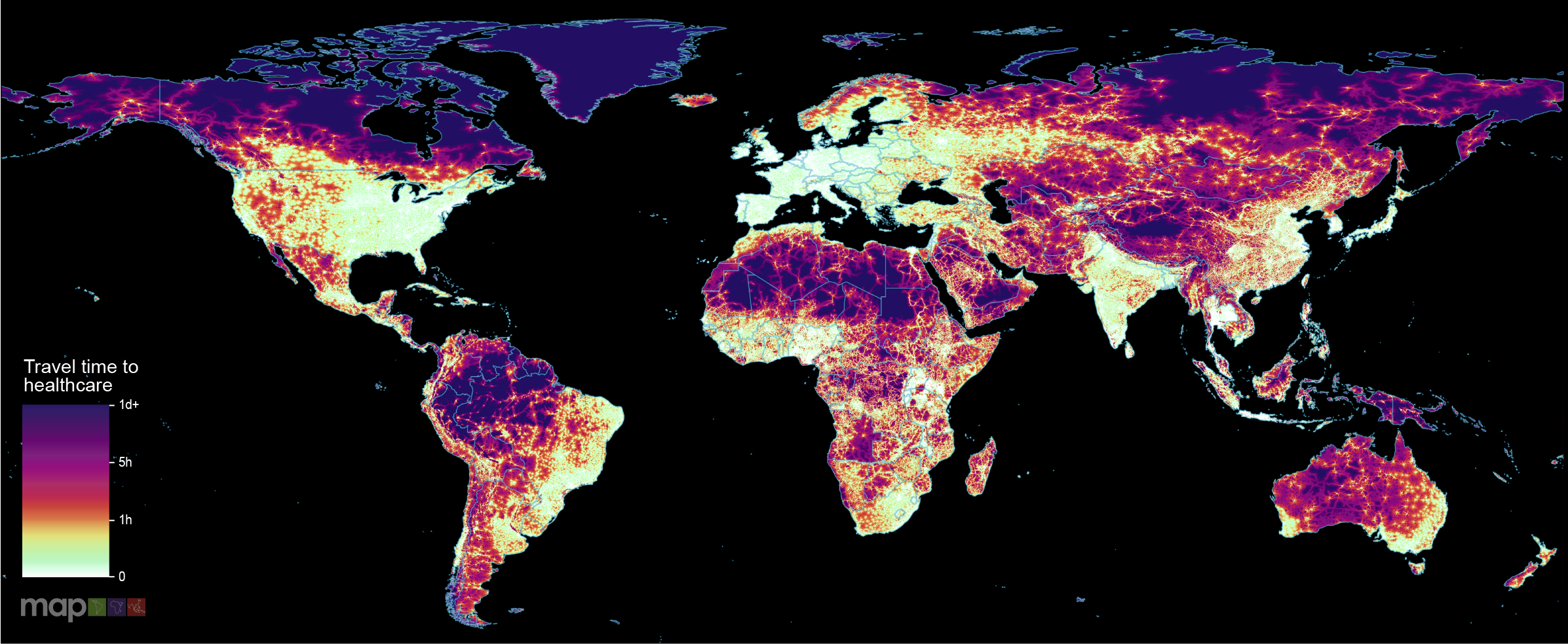
New research which maps the entire global population’s travel time to their nearest healthcare facility has revealed major inequalities in access to healthcare depending on whether people have access to motorised transport or not.
Malaria is a focal disease and more localized in low endemic areas. The disease is increasingly becoming a concern in urban areas in most sub-Saharan African countries. The growing threats of Anopheles stephensi and insecticide resistance magnify this concern and hamper elimination efforts. It is, therefore, imperative to identify areas, within urban settings, of high-risk of malaria to help better target interventions.
In the austral summer of 2021-2022, Australia experienced an unprecedented Japanese encephalitis virus (JEV) outbreak, with detections over 3000 km south of previous occurrences. Given the limited knowledge of JEV transmission ecology in Australia, we developed geospatial models of transmission risk to support the public health response. We created time-varying habitat suitability models for suspected mosquito vectors and ardeid hosts using month-scaled occurrence and covariate data from 2000-2023.
Malaria imposes a significant global health burden and remains a major cause of child mortality in sub-Saharan Africa. In many countries, malaria transmission varies seasonally. The use of seasonally-deployed interventions is expanding, and the effectiveness of these control measures hinges on quantitative and geographically-specific characterisations of malaria seasonality.